Showing posts with label road trip. Show all posts

Thursday, October 19, 2017

Post #20 part 3: The Great American Eclipse 08/21/17 + the Mother Daughter Road Trip

Day 5 - Wednesday, August 23rd
So lucky us to end up at a hotel that caters to local construction workers, breakfast started being served at 5 am. So it was another early morning for Mom and I, we were off to Saskatchewan by way of Montana {Plentywood, Montana, mileage: 5862, time: 06:47 MDT}.

{Leaving US, mileage: 5878.6, time: 07:03 MDT & Entering Canada, mileage: 5878.8, time: 08:25 CDT. Time at Port of Entry: ~22 mins} At the border we were asked a bunch of questions, including how we were planning on paying for things while we were in Canada. One thing that came up while we were crossing the border was our last time in Canada. Mom and I were in Canada back in 2014, we went to Sault Ste Marie and then crossed through the southern tip of Ontario to get back to NY from Michigan. Earlier that same year I went to Canada on my own, kind of.
Funny story: Mom drove up to the border with me, but didn't have a passport or a pass card yet, so I left her on the side of the road in New York while I continued into Canada. I was only going to to. Well, the border officer that let me into Canada thought it was hilarious, the one on the way back to the US did not. That was my first time being stopped at the border.
Back to our crossing into Saskatchewan, I told him that I wanted to see another Canadian province and being on this Eclipse Trip was the best opportunity. He had us park while he ran a background check on both Mom and I. Well come to find out, in my file lists all of my crossings into Canada since you've needed a passport, including the funny story. No joke, in my file are the words: "Left mom on side of road." It's official, I am on a list, and double checked when I make my random trips to Canada.
Turning right on to Rt 18 in Saskatchewan marked the point when Mom and I started heading back to Maryland. We still had a lot to do before getting back to Maryland, but we would no longer be traveling west.
Route 18 in Saskatchewan is a gravel road, in case anyone was wondering, or at least a large portion of it is (44 km). Also, there are no rest stops, and very few towns with convenient stores - never pass up a bathroom. Saskatchewan was flat and empty along Rt 18, which I was exception, and was completely at peace with. I have been to Saskatchewan! We crossed into Manitoba from Saskatchewan, keeping an eye on the time, and figuring out how quickly we would be getting to Grand Forks, ND. Soon after crossing into Manitoba we used our map (we turned off our phones to ensure no international charges) to find the most direct path back to the United States.

We crossed back into the US in Westhope, ND {mileage: 6001, time: 10:52 CDT}. Again we were questioned by Border Patrol officers, and this time they searched our car. We chatted more about our road trip, and ended up heading to Rugby, North Dakota for our next stop - the geographic center of North America. {mileage: 6192, time: 14:15 CDT}


From there it was just across North Dakota on Rt. 2, arriving at Hotel #3: Best Western Harvest Inn in Grand Forks, North Dakota {mileage: 6339, time: 16:28 CDT}. Mom did a load of laundry when we got to the hotel, and then we had dinner with Erica! Erica and I have known each other since 2010 and the Boulder REU. She's at grad school in Grand Forks, and I would have been a fool to come all the way across the country and not see her.

Day 6 - Thursday, August 24th
We left this hotel before breakfast, which is kind of sad because they had a pancake maker. Ah well, from Grand Forks we headed south east for our next stop: the stairs in Stillwater, Minnesota. (Update as of 10/19/17: I stayed at a Holiday Inn Express in Breezewood, PA and was able to experience a pancake maker.) We entered Minnesota at milage: 6418 and time: 06:25 CDT.

Wisconsin: so close, yet so far.
I took a video of us walking up and down the steps, turns out it wasn't as long of a staircase as we were expecting, but the top gave a nice view of town, the St. Croix River, and Wisconsin. Unfortunately, the drawbridge that connected Stillwater to Wisconsin was closed to all traffic so mom and I had to make a driving detour across another bridge, a little south of town, to hit Wisconsin.

From there we headed to downtown-ish Minneapolis to walk out over the Mississippi. Looking around at the city scape I decided I could totally live in Minneapolis, and some day I hope to.

Minneapolis skyline
Always seeking Locks.
Next stop: MALL OF AMERICA! A place I have only ever seen in pop culture: Mighty Ducks D2 and Jingle All The Way being the two most vivid memories. In making it to the Mall of America, I even made it to Hawaii. Mom and I walked around a bit, and rode a roller coaster, the entire ride I kept telling her to put her hands up, she wouldn't do it.
I parked in Hawaii!
Finishing up the sights I planned for us in Minnesota, we were off to Iowa, and the future birthplace of Capt. James T. Kirk, Riverside, Iowa. It was a really random thing for me to select as our stop in Iowa, but in all honesty I just wanted to say I had been to Iowa. {mileage: 7014, time: 19:43 CDT}

Crossing from Iowa into Illinois meant crossing the Mississippi river for the 4th and final time of our Mother Daughter road trip; it also meant that we were back in familiar territory. Our last night before returning to Maryland was spent at Hotel #4: Best Western Oglesby Inn, Illinois. {milage: 7160 ish, time: 22:04 CDT ish}

Day 7 - Friday, August 25th
After breakfast at the Hotel mom and I were on the road again, crossing back to the Eastern time zone, and along roads that we had traversed before. Illinois, Indiana, and Ohio blurred together.
We stopped in Pittsburg, Pennsylvania to see Rachel before continuing on back to Maryland. Rachel asked if we minded walking a ways to dinner, after being cooped up in the car for 10 ish hours, that sounded like a great idea. Dinner was at Burgatory (yum), and mom and I opted for Bison Burgers because we didn't get any bison while we were out west. {milage: 7693 ish, time: 18:15 EDT ish}
After dinner we left Rachel's and drove our last 3 and a half hours back to my apartment in Laurel, MD. It was good to be home, but the trip really was amazing. {milage: 7972 ish, time: 02:00 EDT ish}

Day 8 - Saturday, August 26th
We returned the car at 08:57 EDT with 7978 miles on it. We put (4924) miles on that little Nissan Versa, not to mention all the bug carcasses that were decorating the grill when we returned it.

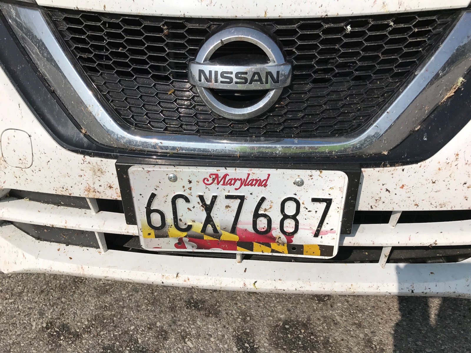
Rental car's front grill before washing...

 So that's it, the chronicles of the Mother-Daughter Solar Eclipse Road Trip. Until our next wild and crazy trip.

States I have been to (AFTER):
Only 4 more states to visit: HawaiiOregonIdaho, and Vermont (being from New York, this last one upsets me).
Key: Green - spent more than a week there/lived there, Blue - spent a week/visited many times, Orange - visited once or twice/seen some sites, Red - been in/whirl wind visit

Tuesday, October 3, 2017

Post #20 part 2: The Great American Eclipse 08/21/17 + the Mother Daughter Road Trip

Day 4 - Tuesday, August 22nd
So the Bessey Recreation Complex was a nice facility. The bathrooms were clean, and the sky was so beautiful during the night. Mom and I chose to sleep in the car again because we wanted to leave early. Trying to take down a tent in the dark might have been difficult. Good thing we didn't because we ended up leaving at nearly 4 AM. We didn't intend to leave that early, but the campsite was next to the train track, and after midnight there were trains every hour, blowing their horns and waking us up. So we left Halsey and headed towards Mount Rushmore.
Left campsite and crossed into MDT.
Made it to Mt Rushmore


Funny thing, we left the campsite with a little over a half of tank of gas, well that was just enough to get to the next gas station. Mom and I made it to Alliance, Nebraska with 11 miles to spare {mileage: 5164 time: 06:00 CDT}. We were going through Alliance before the sun came up, so we didn't see Carhenge.


But we did get to Mount Rushmore {mileage: 5317 time: 07:45 MDT - 10:10 MDT} by 07:45 AM, which was great. TIP: If you are planning a trip to Mount Rushmore, GO EARLY!! We got there at 7:45 and there were no lines no waiting, but when we left around 10:10 there was a line from the gate all the way down to Keystone. Mom discovered, after we got there, that Mount Rushmore opens at 5 am. Had she known that beforehand we probably would have tried to get there earlier.
I'm serious, like the presidents
Mom with a picture of Lincoln, in front of Lincoln
Our time at Mount Rushmore helped us stretch our legs and get some cardio in. We had been in the car so much. I joked that we could jog the trail, mom took me seriously so that is what we did. We started jogging and stopped at each of the photo points.
Funny anecdote, at the very first stop there was a couple and the wife joked that she only runs when she is being chased, so we chatted a bit about the road trip and the eclipse. They were able to watch the eclipse in the middle of a field in Wyoming, but didn't get ay pictures of totality. Mom had, so I asked if they wanted me to share them. We did AirDrop, but what was funny is that the husband's information popped up on my phone, so I asked "Are you Kevin?" Well, I wasn't looking at his face, but mom said his reaction was amazing; shock and confusion. It was very entertaining.
We did two loops on the Presidential Trail, the first at a jog with stopping at photo ops and the maker's museum. We went into the little museum and the gift shop, and by the start of our second loop the main viewing area had started to fill up. Mom said that we would have to power walk the next loop. We did almost a full loop, making it to the top of the hill and back to the parking area, then we turned around and when back the other way. Going the other way meant we had to go UP all the stairs that people usually go down because they go clockwise from the entrance. It certainly got our blood pumping and sweat flowing. Good workout, aside from all the tourist getting in the way.


After Mount Rushmore we headed towards Wyoming. Mom tried to make me nix this part of the trip, but I was hell bent on getting to Wyoming. We crossed the border of South Dakota and Wyoming and stopped at their Welcome Center/Convenient Store/Post Office/Gas Station combo {mileage: 5403 time: 12:43 MDT}. We got some post cards and mailed them out - how convenient that they had a post office right there.


On our way back to South Dakota (we were getting to Campsite #3 by way of South Dakota), we stopped at their welcome center, which was a great idea because we discovered something interesting that was going to be along our route to Medora, ND: The Geographical Center of the United States, the real one that is out in the middle of a field, north of Belle Fourche, SD {mileage: 5457 time: 15:54 MDT}. That was a fun detour.
So from there we continued towards the Cottonwood Campground in North Dakota, following the directions from the AAA triptik. We were feeling good, we were actually going to get to a campsite early enough to walk some of the trails, although Mom wasn't looking forward to this campsite; no showers and only vault (non flush) toilets.
A right on to East River Road and we would be there. Well that right took us up a hill and no campsite was found. For no more than a half hour I though we were going the right way. We were driving through the beautiful Badlands. The strata you could see in the hills was cool toned, greys and reds. The prairie grass was a muted green and the road we are on was gravel. Our rental car was getting so dirty (bugs + dirt). There were beef cows grazing very near the road, within a cars' width of us. There were also a large number of oil pumps scattered alongside the road.
Mom and I were laughing most of the way, knowing we were lost and were not finding the campsite. But the sun was shinning and the views were unlike anything we had ever seen, all was well. It was as the sun was setting and daylight was fading did we really start to worry.
No zoom necessary
We had plenty of gas at least, but our cell phones had no service. Mom suggested that we turn around. I thought we had come too far to turn around, we had to be getting somewhere, I suppose the real question was: Where? I made the mental decision that at a quarter of a tank of gas we could turn around, that way we definitely had enough gas to get back. But once we had enough of being lost I had my mom watch Google maps on my phone as I drove and tell me when we had service. I would stop and analyze Google maps to determine where we needed to go.
Disclaimer: Mom and I know how to read a map, if we had a map of this area we would have been fine.
The view on the left side of our dirt road
The view on the right side of our dirt road
Once we finally got out of the Badlands, and back on to paved roads we found a hotel, we ended up an extra hour or so north in Watford City, North Dakota. So we were supposed to end up at Campsite #3: Cottonwood Campground in Medora, North Dakota, but we failed and then ended up at Hotel #2 Little Missouri Inn & Suites, Watford City {mileage: 5734}. Once getting into the hotel and onto the wifi I checked... if we had turned left on East River Road we would have made it to the campsite. Also, the campsite was off interstate 94. Sigh.

Screen shot of the map when we had service
Screen shot of the directions when we had service

Thursday, September 7, 2017

Post #20 Part 1: The Great American Eclipse 08/21/17 + the Mother Daughter Road Trip

States I have been to (BEFORE):


Eclipse Trip plan: Maryland -> West Virginia -> Kentucky -> Tennessee -> Missouri -> Arkansas -> Oklahoma -> Kansas -> Nebraska -> South Dakota -> Wyoming -> North Dakota -> Montana -> Saskatchewan -> Manitoba -> North Dakota -> Minnesota ->  Wisconsin -> Iowa -> Illinois -> Indiana -> Ohio -> Pennsylvania -> Maryland

PreTrip:
As of 08/10/2017: Predicted Solar Eclipse weather in Beatrice, Nebraska - BEAUTIFUL!
As of 08/14/2017: Predicted Solar Eclipse weather in Beatrice, Nebraska - It'll be okay...
As of 08/15/2017: Predicted Solar Eclipse weather in Beatrice, Nebraska - Nice
As of 08/16/2017: Predicted Solar Eclipse weather in Beatrice, Nebraska - Hot.
As of 08/18/2017: Predicted Solar Eclipse weather in Beatrice, Nebraska - Err...

Now to the trip:

Right before leaving, Mom and I with the Nissan Versa Hatchback
Day 1 - Saturday, August 19th
The rental car reservation started at 9 am, earliest available, we got the car with 3054 (0) miles on it. My mother and I left from my apartment in Laurel, MD at mileage = 3060 (6), time = 09:54 EDT, heading west.
Welcome Center - West Virginia
We took the route that would take us through West Virginia and Kentucky, instead of Virginia into Tennessee, because I have no memories of ever being in the state of Kentucky (my mother said we went, or at least drove through, there when I was a baby).
Welcome Center - Kentucky
We drove towards the World's Largest Collection of Teapots in Trenton, TN. The stops along the way included the Welcome Center {mileage = 3285 (231), time = 14:16 EDT} in West Virginia and a rest stop in Kentucky {mileage = 3493 (439), time = 17:29 EDT}.
Night number one we spent in Peducha, Kentucky, Hotel #1: America's Best Value Inn, mileage = 3847 (793), time = 11 CDT ish (Peducah was on the path of the 2017 Great American Eclipse, and [fun fact] it is also on the path for the 2024 solar eclipse.)

Day 2 - Sunday, August 20th
Largest Collection of Teapots, Trenton, Tennessee
Leaving Kentucky and heading to Trenton, Tennessee. Mom and I left from our lack luster breakfast at the hotel around 06:30 CDT. The road down to Trenton was a country road, with crops growing on either side. Trenton, TN is known for two things on the Roadside America website: 31 mph speed limit and the largest collection of teapots. The 31 mph speed limit was amusing to see, and from the internets I read that the speed limit was to one-up the neighboring town.
8AM CDT outside the museum
The teapots are housed in a room that is connected to the police station, so was available for my mother and I to view at 8 am on a Sunday. The doctor who owned this collection had the requirement that the exhibit be viewed for free forever. Mom and I donated because Trenton does a lovely job of presenting the collection, complete with a video explaining the history of the exhibit {mileage: 3938 time: 08:02 CDT}.


From our brief stop in Tennessee we continued into Missouri, crossing the Mississippi River for the first time. Rt 60 in Missouri was not the most picturesque roadway, and mom wasn't particularly excited about all the 'casinos' we saw along the way. It was while we were in Missouri that we switched the music over to Sirius XM, which we used for the remainder of the road trip.
Arkansas
Missouri
Oklahoma


Our next stop was the Tri-State Marker in Sulphur Springs, Arkansas. It was at this marker that I stepped foot into Oklahoma and Arkansas for the first time {mileage: 4354 time: 15:28 CDT}. We made a brief stop in Fort Scott, Kansas for Dairy Queen {mileage: 4464 time: 18:07 CDT}. From there it was off to Campsite #1: Tuttle Cove in Manhattan, Kansas, mileage: 4668.

Pony Express Historical Marker
Day 3 - Monday, August 21st
Mom and I left the camp grounds in Kansas at around 5:30 am CDT, setting out for our target, the Homestead National Monument in Beatrice, Nebraska. While traversing northern Kansas we identified a Historic Marker. Turns out this historic marker was a stop along the Pony Express (Mileage: 4724, Time: 06:38 CDT).
CORN!!
Matching Shirts I made for Mom and I
                               
At 4764 miles from 07:32 - 14:16 CDT Mom and I were at the Homestead National Historic Site with tons of other people. We got a schedule, and walked around the museum. During our first hour there we discovered a special guest was going to be in attendance, BILL NYE, the science guy! We had no idea, what a great surprise. He spoke on a panel and gave interviews, and then during the time leading up to, during, and after totality he was narrating what was happening. Of course his presence there was targeted to the grade schoolers instead of the ones who truly appreciated his presence (ahem, me and the other nearly 30s that watched his show growing up).
The Homestead location even had a mobile post office on site where people could buy the Eclipse Stamps, and mail post cards with the special Eclipse Postmark.
BILL NYE!!
As my time mark shows, we stayed for about an hour after totality, waiting for some of the traffic to die down. Unlike the majority of my friends, who were also on the path of totality, Mom and I didn't get stuck in ANY traffic when we left. We were headed further west, towards out second campsite. We stopped briefly in Grand Island, NE for some dinner (Olive Garden Salad and Breadsticks), then continued to Campsite #2: Bessey Recreation Complex in Halsey, Nebraska, getting there at 20:59 CDT at mileage: 5027.

More adventures to come.